Review: London’s South Bank – The History by Mireille Galinou. A guest post by LH Member Hannah Renier.
Illustrations by Stephen Conlin. Foreword by Simon Thurley.
“This beautifully illustrated book, an innovative classic by an awesome historian. Get it now!”
 London’s exact geographic centre is disputed, but is known to lie within a few hundred yards of Waterloo Bridge, south end. Much of London’s cultural vibe begins here too. But the ‘South Bank’ of the Thames is far more than a strip of riverside featuring the Festival Hall, and for the purposes of her book Mireille Galinou has had to define exactly where it begins and ends. She chooses the Thames bank from Vauxhall to Bermondsey—which neatly takes us from pre-history to Southwark, with its bridge to Roman London. The area’s bookends on the Thames are its tributaries the Effra, which pours in at Vauxhall, and the Neckinger in Bermondsey—both, of course, now underground.
A shortcut by car across its hinterland today might run from Vauxhall Bridge along Kennington Lane to Newington Butts, with a swerve around the Elephant and Castle to the New Kent Road and another swerve at Bricklayer’s Arms to Tower Bridge Road. It would include the leafy avenues of Georgian Kennington, Newington (the Elephant) and ancient parts of Bermondsey that aren’t on the river. And as if to prove consistently correct definition through the ages, Galinou’s choice of boundaries would follow the line of defence built around London in 1642 when Charles I, who’d fled to Oxford from London’s angry populace, was scheming to return at the head of a Royalist army. To deter him, a chain was slung across the Thames from Vauxhall to what is now Pimlico, and another chain from Bermondsey to Wapping, while fortifications between the two were built along the land route described above and around the City and Westminster.
For Roman Londoners, as for the city reconstructed over a thousand years ago, much of the fun was on the south side; it still is. Sadly, for London’s first 1,750 years or so the only crossing point was a single overcrowded bridge, or a boat. We now have plenty of bridges, and commuter boats, and the wonderful Thames Path whose south side you can walk almost unimpeded from Woolwich to Kingston.
Galinou discusses why South of the River (all of it) is absent from the mental landscape of many Londoners, even today. (See for explanation Saul Steinberg’s New Yorker cover, View of the World from 9th Avenue). Excuses for this gap in consciousness are credible though lame. For instance, when they founded London, the Romans buried their dead outside the City walls, and the fourth wall faced Southwark; a reputation as a burial ground was bad optics. Also, in the earliest years of Roman occupation Southwark meant shacks on a flotilla of mudbanks, and until the middle ages, the land for miles beyond the riverbank was marshy, and therefore unhealthy: ague is malaria. Later, expert artists from abroad produced images of the City and Westminster seen from the best panoramic viewpoint. This was on the south bank, which usually meant leaving the south bank out.
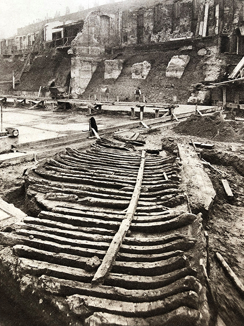
Roman boat recovered in 1910 during the construction of County Hall
With time and human intervention, the mud turned to fertile soil, market gardens and orchards thrived, produce could be shipped to market at Covent Garden and you could catch fish upstream and take them to Billingsgate for sale. Pepys could cut across the headland on foot and enjoy his walk across flower-filled meadows. Industries flourished along the southern riverbank, everything from lime kilns to windmills, barge builders, gunmakers, breweries, potteries and glassworks. Industry, too often smoky or smelly, meant that on the north side many Londoners still saw the south bank as a poorer, dirtier place. Palaces belonged on the Strand or St James’s, the world of fashion and intellect was in Mayfair, the fate of the nation was decided in Whitehall, lawyers were in Temple, and luxuries and money were traded in the City. There was little reason to seek one’s pleasures over the river, except in the fashionable years of Vauxhall Gardens.
It is true that by the late 1930s the South Bank was desperately polluted and poor. But that was nearly a century ago. In the twenty-first century we take it for granted that our friends and neighbours may have arrived from any country in the world. Yet I was astonished, a few years ago, to see two members of what looked (to me) to be a Chasidic community excitedly exploring the Vauxhall to Battersea Thames Path on Boris bikes. Stamford Hill, I thought. They’ve come all that way! Next summer, these first brave scouts were followed by whole families from the same community, with multiple babies, picnicking happily in Battersea Park. Now we have Chanukah lights at Vauxhall tube every year alongside the Christmas tree. Rejoice! North London has finally discovered what they’ve been missing.
This book may well inspire more Londoners to explore what’s going on beyond their own village. Every page is colourfully illustrated with maps and pictures, many rarely published before, and splendid original work by Stephen Conlin which helps us navigate the story.
Galinou’s focus is mainly on paintings and gardens, although industry and medicine come a close second. In her enthusiasm she’s found out so much that the outcome is hard to organise. Should the story be based on chronology, or should the narrative identify each important location separately and set it in its context? When you open a book of local history you can generally assume Chapter One will be about sometime long, long ago – but this is more complicated, and the better for that.
You need to spend a few minutes learning how the whole thing works. The author has chosen a clever compromise between chronology and place. Thanks to scholarship, prolific illustrations and pictorial maps, and clear cross-referencing within the text, the result is somehow three dimensional. Every section looks at the South Bank from a different angle.
After a Prologue, a whole chapter full of pictures shows how the this place has been depicted over time, and by whom.
In the next chapter, the South Bank is explored by location and time, in four districts. From the upstream end: Vauxhall and Lambeth; Waterloo; Borough and Bankside; Southwark and Bermondsey. History has left its mark in every one of those four places – so we see each one first in approximately 1600; then 1770; then in 1845, and finally, now. Prisons, gardens, museums, palaces, nunneries, cemeteries, pubs, churches, tanneries, theatres, hospitals, factories and mills, schools, many of them long gone but many, still here; we can read all about them and see pictures. This place has been home to philanthropists, prizefighters, ‘lunatics’, preachers, scientists, actors, impresarios, industrialists and property developers many of whose names are well known. Galinou is a doggedly curious and experienced researcher whose investigations uncover fascinating stories.
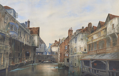
J L Stewart, Jacob’s Island, Bermondsey, watercolour 1886 © Museum of London
All four districts have had moments in the sun, and times when they were squalid or at least undesirable. But change on the whole has been good. Borough Market has been enlarged and improved and is now a magnet for every foodie. Bomb damage along the South Bank was devastating, but the Festival of Britain and the theatres, galleries and cinemas that were built on its site are a triumph.
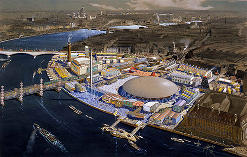
John Dean Monroe Harvey, Bird’s eye view of the 1951 Festival of Britain. The National Archives (UK) ref. WORK24/64/25
‘The Quest’ is another chapter. Rejecting Baudelaire’s placid ‘flâneur’, an idler who delights in simply strolling, listening and observing the city, Galinou declares
The purpose of this book is dynamic. Parts of it rely on walking and absorbing the random, never-ending manifestations of the city; but the ‘search’ engine is turned on, which means looking for meaning and seeking to discover significant clues….I will make a determined attempt to find the city’s soul.
Again she examines each of the four districts in turn, but now identifying a unique thread running through each of them. In every district are links, similarities that spring up after centuries like long-dormant poppies and can’t be explained away. Those of a rational bent will quickly dismiss the whole idea of a ‘spirit of place’ and seek a historical explanation for this. Sometimes that can’t be found. On the other hand, a deep dive into psychogeography seems plain silly (it’ll be ley lines next). Galinou is brave enough to explore the ‘soul’ of each district and treads a fine line with care.
In ‘Paradise Regained’, Vauxhall and Lambeth, the link across the ages is gardens, greenery, landscape, fun. In the Waterloo section, which is ‘Fall and Redemption’, philanthropy and despair, ignorance and education, bomb damage and public protest have resulted in today’s triumphant stretch of riverbank. (The station itself can’t be tackled fully until the next economic boom.) The Borough and Bankside – ‘Sinners and Saints, Life and Death’ is next, and the Borough identified as the Larder of London. The Southwark and Bermondsey section is called ‘The Highs and Lows of a Strategic Neighbourhood’. Southwark Cathedral, for centuries the most prominent building on the South Bank, is now dwarfed by the newest London icon, the Shard, sparkling at all times of day and night, visible from just about everywhere on the South Bank and the hills surrounding London, too.
Unexpected discoveries can spring from radical change. Archaeologists have found burials, ancient artefacts and tesselated Roman flooring here which would have lain hidden had it not been for access to new construction sites.
In a city like London the past is a whirling kaleidoscope of memories. Ten years ago the Shell Centre was a landmark; now it’s barely noticeable alongside a forest of expensive apartments. In 2007 the train from Paris ended in Waterloo Station and Nine Elms consisted of bleak low-rise depots strung out along a featureless highway. It was 2012 before credible owners bought and planned to revive the derelict Battersea Power Station as a landmark, an American Embassy was in the pipeline, other developers snapped up land, New Covent Garden market shifted, the Thames Path was extended and conversion of wasteland to a small town of high-rises, bars and restaurants began. London Bridge station, the oldest terminus in London, was grubby and overcrowded in 2010; now it is graceful and spacious. Murky old Hungerford Bridge has been replaced by two sparkling white pedestrian walkways either side of the railway line, and the Thames Supersewer construction work is nearing completion in 2025. It will restore access to parts of the Thames Path which have been temporarily obstructed, and provide a few new viewpoints as well.
Contemporary descriptions of London go out of date fast. Yet decades from now, this book will still be enjoyable and revelatory. I don’t think any London Historian’s life will be complete without it.
______________________________________________________
London’s South Bank – The History (584pp, richly illustrated) by Mireille Galinou is published by Your London Publishing with a cover price of £35 but available for less.
